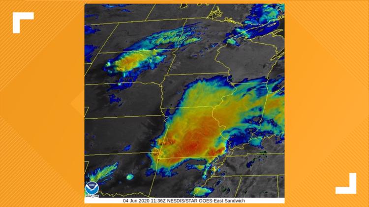
Early Thursday morning, meteorologists at the National Weather Service in Kansas City witnessed something that their on-call team had never seen before: a west to east propagating Mesoscale Convective System.
What is a Mesoscale Convective System?
A Mesoscale Convective System is a collection of thunderstorms that act together as one weather system lasting for more than 12 hours. They are most common in the summer months across the Plains, Midwest and Dixie Alley. A MCS can bring heavy rainfall that can lead to flash flooding, severe thunderstorms, and even weak tornadoes throughout it's lifespan. Furthermore, these weather systems can eventually become their own weather system and create new areas of low pressure. And that's what happened early Thursday morning.
Late Wednesday, two separate MCS's developed over the Missouri Valley, one in eastern Kansas and another over the St. Louis area. And as the two grew in tandem, the MCS over St. Louis began to slowly grow to the west, leading to a east to west propagation of the entire weather system. The National Weather Service Office on Twitter wrote about it as, "not out of the realm of possibility, but for us on shift it's something we've never witnessed in real time."
Thursday morning's "backwards" moving MCS is an example of having the right conditions (or lack there of) in the right place and time. First, there was minimal forcing above the MCS, like a strong jet stream, to tear the system apart or forcefully move it from west to east, like the eastern Kansas MCS did. And for the MCS to continue to grow as it did, there was plentiful moisture, instability, and rising motion in the region.
So while these Mesoscale Convective Systems are relatively common for this region and time of year, Thursday morning's edition over the Missouri Valley is an example of how meteorologists are continuing to learn as they monitor the atmosphere.


