BUFFALO, N.Y. — This winter looks to be similar in some ways to last year, but Storm Team 2 is looking at multiple factors for this year's 2024 Winter Outlook.
We have a weak La Niña whereas last year an El Niño was in charge. However, we are also watching different global patterns that will impact our winter. And the very warm Lake Erie will come into play once again.
But, let's start with the projected snow totals for the winter and take a look at our different zones to see how the snowfall will vary.
Buffalo Zone
We will start off in our Buffalo zone. We expect snowfall will be slightly below normal and temperatures trending a bit above normal. However, we may see some healthy snowfall events once again. We are calling for 80 to 90 inches of snowfall for the winter season. The average is 94 inches.
Northern Zones
For our northern zones, look for snow total in the 50 to 60 inch range. This includes places like Niagara Falls, Lockport, Lewiston, and Albion.
Southtowns
Moving on to the Southtowns, snowfall totals near the lakeshore are expected to be in the 70 to 90 inch range, with upwards of 120 to 140 inches in the hills.
Southern Tier
Into the Southern Tier, we are looking at a larger range from 80 to 180 inches with those higher amounts over ski country and the higher terrain including the Chautauqua Ridge. Lower amounts of snow are expected in places such as Olean, Wellsville and Jamestown.
So how did we get this forecast?
Here's a little bit of the WHY.
When meteorologists make season-long forecasts, there are a few naturally occurring climate variables to take into consideration. The most well known is El Niño. It's projected to enter a negative phase, which is nicknamed La Niña. That means cooler than average sea surface temperatures in the eastern Pacific, which can alter the path of the jet stream. For the Great Lakes region, we typically lean a tad warmer and have a tad more precipitation than normal.
La Niña weather patterns have become a bit more frequent. In fact in the past 10 years, five years have featured a La Niña. However, going back 70 years there have been 16 seasons with a weak La Niña, which is what is forecasted this winter. During those winter seasons, eight have featured above normal snowfall, five below normal snowfall, and three with average snowfall. So historically, weak La Niñas have a greater chance at normal to above normal snowfall.
But again, La Niña is just one of several climate factors we need to examine.
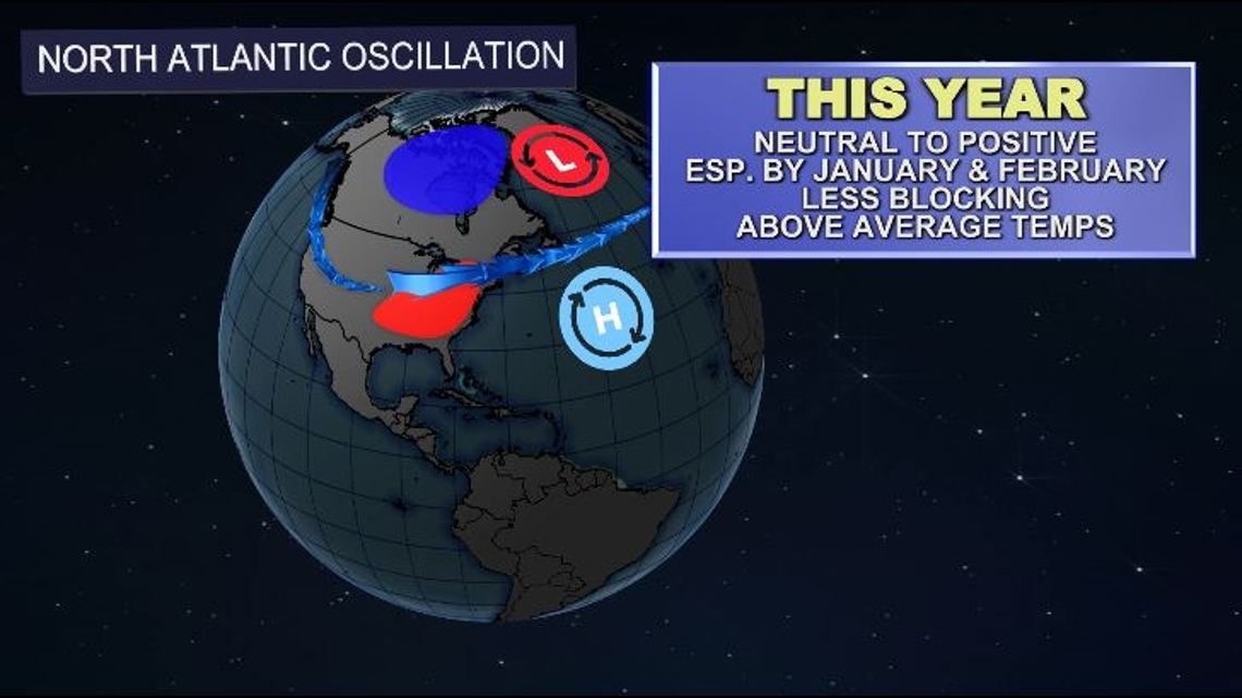
Another climate factor that we look at has to do with a different ocean. This time we look to the Atlantic ocean and a weather pattern called the NAO, or North Atlantic Oscillation.
Unlike the El Niño Southern Oscillation, which looks at sea surface temperatures, this is where we look at sea level pressure. In particular, an area of low pressure near Iceland and and area of high pressure near the Azores which is in the central Atlantic.
When these pressures are stronger than average we have a positive NAO and it's a negative NAO when these pressures are weaker than average. When we have a negative NAO, that's when we can expect extended periods of cold and wintry weather. This year, we're anticipating a more neutral NAO to start winter, but more and more positive by January and February which increases the chance of milder winter conditions.


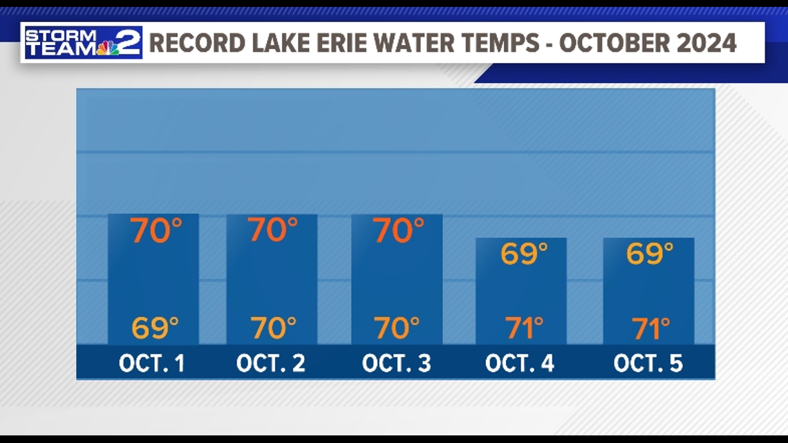
Lake Erie always plays a factor, and this year the lake water continues to be very warm, even record breaking once again for the first part of October, like last year, hitting 70 degrees for many days. This year the lake also tied record highs for much of the first part of November. The lake is once again a large source of fuel for big lake effect snow events potentially for the first part of winter. Even if we have melting in between snow events like last year, plan for some decent snow at times.


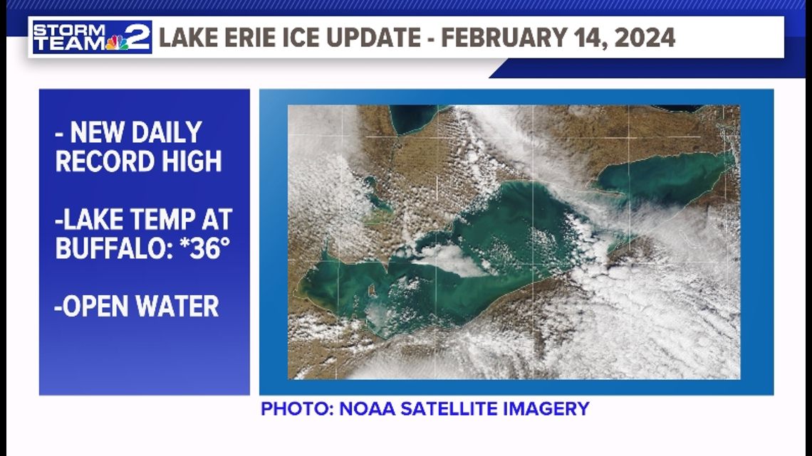
There is also a continuing trend of Lake Erie not seeing as much ice cover, and not freezing over in the winter as often. The water is reaching record warmth more often even in February, during the normally coldest part of the year. This is becoming more common in the most recent two decades.


Data shows Lake Erie's ice cover is changing over time, with fewer years of the lake freezing over in recent decades, and that trend appears to be accelerating. This is likely a contributing factor to more frequent major lake effect snowstorms locally.
As long as the bursts of arctic air come down over a warmer Lake Erie and the winds set up with a west southwest flow ideally, these are some of the major ingredients needed for lake effect snow events.
Note, this winter's expected snow totals could be on the higher end of what we may see, based on just how many lake effect snow events we get locally. The snow totals this season could be a little lower than these projections.
Last year Storm Team 2’s Winter Outlook verified, with the prediction of snow totals just a few inches off from the received winter snowfall in Buffalo, also predicting big lake effect snow events with melting in between. The strong El Nino set up last year and a very warm Lake Erie gave a more straight forward forecast. This year is a bit more complicated. There is a weak La Nina setting up and other weather patterns locally and globally look to impact our winter weather this season.
Stay tuned to Storm Team 2 throughout the winter!

