
BUFFALO, N.Y. — The National Weather Service in Buffalo issued winter weather alerts for most of Western New York ahead of a wintry mix that could lead to slippery roads Friday evening.
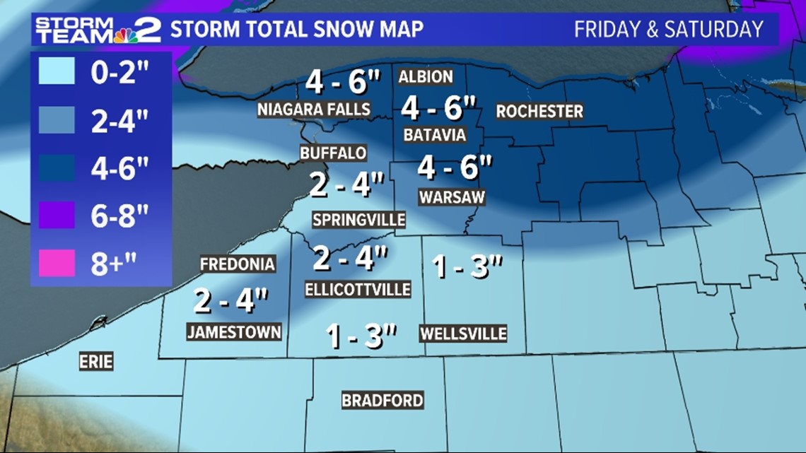
A Winter Weather Advisory lasted until 10 a.m. Saturday for Niagara and Orleans counties. Snow accumulations between 4 to 8 inches plus some sleet mixing and wind gusts up to 35 mph could lead to hazardous travel and road conditions.
A Winter Weather Advisory was in effect until 10 a.m. Saturday for Cattaraugus, southern Erie, and Allegany counties. A wintry mix with snow accumulations between 2 to 4 inches is expected. Slippery roads are the main concern.
A Winter Weather Advisory for Wyoming County was in effect until 10 a.m. Saturday. 3 to 6 inches of snow plus ice accumulations up to a tenth of an inch from sleet is expected, leading to slippery roads and icy conditions. Wind gusts up to 45 mph could lead to localized power outages.
A Winter Weather Advisory for northern Erie and Genesee counties was in effect until 10 a.m. Saturday. Snow and sleet is expected with mixed precipitation accumulations between 3 to 6 inches. Wind gusts could also reach up to 40 mph, leading to hazardous travel with slippery or snow covered roads.
A Winter Weather Advisory for McKean and Potter counties in northern Pennsylvania was in effect until 9 a.m. Saturday. Snow and sleet accumulations of 1 to 3 inches could lead to slippery roads. Wind gusts up to 40 mph could lead to localized power outages.

An area of low pressure will spin through the Great Lakes Friday night and continue to produce a wintry mix of rain and snow. One thing's for sure, this system will have a lot of moisture and some warm air as it's coming from the south. By 9 p.m. Friday evening, much of Western New York had already picked up a slushy mix of rain, sleet and snow. Snow accumulations from portions of Erie, Niagara and Wyoming counties ranged between 1 to 3 inches.
This wintry mix of rain and snow showers will continue overnight with additional snow accumulations between 1 to 3 inches tops expected overnight. That's as colder air funnels in, leading to all snow showers by Saturday morning. Scattered snow showers will linger into the early afternoon Saturday.
Anticipate snowy or slippery roads throughout the duration of the advisory. There is also the chance for localized power outages too with wind gusts up to 40 mph at times.
- FORECAST: Storm Team 2 weather outlook for Western New York
- CLOSING CENTRAL: Closings and delays
- STORM TEAM 2 RADAR: Radar map