BUFFALO, N.Y. — There is a growing chance of an impactful lake effect snow event later this week and weekend for portions of Western New York.
A Lake Effect Snow Warning for Cattaraugus, Wyoming and Chautauqua until 10 p.m. Thursday. A Lake Effect Snow Warning is also in effect for southern Erie County through 1 a.m. Saturday. Northern Erie County and Genesee County also have a Lake Effect Snow Warning from 7 p.m. Thursday through 1 p.m. Sunday.
And another Lake Effect Snow Warning will be in effect Niagara County from 7 a.m. Saturday to 7 a.m. Sunday. A Winter Weather Advisory is in effect for Orleans County from 7 a.m. Saturday to 7 a.m. Sunday.
Multiple heavy, lake effect snow bands could develop beginning as early as Wednesday evening and lasting through Sunday evening. It's not out of the question that two to three feet of snow could accumulate over this timeframe, leading to significant travel impacts. This includes the Buffalo metro area.
A favorable weather pattern will develop by the end of the week that could cause a prolonged period of cold air over a warm Lake Erie. The lake is currently quite warm and just measured tied a record warm temperature for the date Thursday at 52 degrees. The temperature difference between the warm lake and cold air, plus a favorable wind direction reinforced by several systems passing to the north of Buffalo, could allow for several bands of lake effect snow showers to develop between Thursday and Sunday. The intensity of these bands could be quite impressive, with snowfall rates of 2 to 4 inches per hour.
This lake effect began Wednesday night across the Southern Tier with the region picking up 3 to 14 inches of snow. It's then Thursday night when a more favorable wind direction will settle in over the lake, allowing for lake effect snow band to begin to develop and travel north to Buffalo. This is looking more like a classic, lake effect set up Friday through Sunday with a band of very heavy snow, which could reach up to snowfall rates of two to three inches an hour. With snowfall rates that high, travel conditions could become extremely dangerous.
By Friday night, snow accumulations will range greatly depending on where the band sets up, but towns across the greater Buffalo area and southern Erie County could pick up one foot of snow by then, approaching two feet. Then this lake effect band will begin to lift north of the city, into northern Erie County and Niagara Falls and Niagara County for Saturday. Saturday will be the snowier day then for areas north of the city, picking up potentially a foot of snow by the end of the day.
Finally heading into Sunday, this event will begin to shift back south across Buffalo and the Southtowns, potentially picking up another foot of snow by Sunday evening.
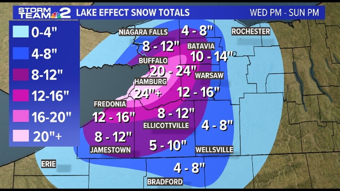
Here are the Western New York event snow totals, beginning Wednesday night through Sunday evening:
Southern Tier: Around 5 to 10 inches of snow across central and southern Chautauqua and Cattaraugus counties, with most of that falling Wednesday night into Thursday. Allegany County will pick up 3 to 6 inches of snow Wednesday into Thursday with minimal impact for the weekend lake effect event there. As for the lakefront area of Chautauqua County and the northern tip, plus northern Cattaraugus County, that could be 12 to 16 inches of snow, upwards of 20 inches.
Southern Erie County: This could be the bullseye of the event if the band of lake effect snow this weekend stay south. Around 2 to 5 inches of snow will accumulate there Wednesday into Thursday morning with the heaviest snow falling Friday and Sunday. Upwards of 24 to 36 inches of snow or more for this area.
Buffalo: The city could also be the bullseye of this event if the band sets up farther north late Thursday night and into Friday and doesn't move. That being said, the city will be the midpoint if the lake effect band oscillates Friday through Sunday. Snow totals around the city will likely be over a foot, approach two feet even. Around 20 to 28 inches for the city as of snow.
Wyoming County: Snow totals will decrease from west to east across the county with around 12 to 16 inches of snow on average, upwards of 20 inches in the far western portion.
Northern Erie County: This is where the forecast could be tricky with the lake effect band likely being just out of reach. Still, a range of 10 to 20 inches for northern Erie County isn't out of the question with the heavier totals closer to Buffalo.
Genesee County: Similarly to Wyoming County, now totals will decrease from west to east across the county with around 10 to 16 inches of snow on average, upwards of 20 inches in the far western portion.
Niagara and Orleans Counties: If this lake effect band migrates north Saturday, which many computer models still have, then this region could pick up 10 to 14 inches of snow. more likely, snow showers just clip this region and bring 8 to 12 inches at the most, more so around 4 to 8 inches if the band doesn't reach that far north.


