BUFFALO, N.Y. — With La Niña conditions present in the Equatorial Pacific, stronger tropical systems and a variable polar jet stream pattern are possible from now through February.
In the latest advisory issued Thursday by the Climate Prediction Center (CPC), it was announced that La Niña a conditions are currently present in the Equatorial Pacific and will likely continue into the wintertime months. Even though this natural phenomenon is located off west coast of South America in the Pacific Ocean, it's impact and influence can be felt across the North America, especially in the fall and winter months.
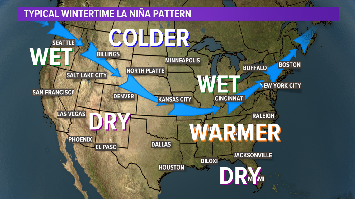
Specifically, CPC is forecasting a 75% chance for the current La Niña conditions to continue through February. While it'll likely be a weaker version, below is the typical wintertime jet stream pattern and result of previous La Niña winters.


In a La Niña wintertime pattern, the polar jet stream tends to dip farther south across the continental United States. The results of this jet stream pattern varies by location. For the Great Lakes, this typically means a wetter and colder winter. The Southeast, a warmer and drier winter. Pacific Northwest, wetter, and Southwest, drier.
These results even vary depending on how strong the La Niña is. The last La Niña to be present across the U.S was in the winter of 2017-2018, but it was relatively weak. The last strong La Niña occurred during the winter of 2010-2011, where Buffalo experienced one of the snowiest February's on record with 34.1 inches total for the month. With the current data and prediction methods, looking back to the winter of 2017-2018 could provide a good estimate as to how this year's La Niña influenced winter could turn out.
A La Niña is a naturally occurring ocean to atmosphere phenomenon marked by cooler than average sea surface temperatures across the Equatorial eastern Pacific Ocean.
The opposite is an El Niño, where warmer than average sea surface temperatures would be present in that region. This part of the ocean naturally fluctuates between having warmer than average or cooler than average temperatures on an yearly basis. It's typical to have a few years of one before it changes to the other though. For example, a La Niña pattern held through the winters of 2016-2017 and 2017-2018 before slowly phasing to El Niño conditions for the winters of 2018-2019 and 2019-2020.
And with La Niña conditions already present, this could lead to stronger tropical systems for the rest of hurricane season, which stretches through the end of November. September 10th is around when the season peak, where seven potential or named storms were already present in the Atlantic. That's definitely a sign of a La Niña influenced pattern and season.


